11 Best Hiking Trails in Portugal: Hikes, Treks, and Facts


- Daniel W.
- From
- Daniel W.
- From
- Julia S.
- From
- Liam R.
- From
Best time to hike in Portugal
The best time to hike in Portugal depends on where you are headed. Generally, spring (April to June) and autumn (September to October) are great for hiking on the mainland as the weather is mild. Madeira and the Azores enjoy pleasant temperatures throughout the year, making them great year-round destinations; however, October to April is the rainy season so you might want to check the trail condition before embarking on a hike. For a more detailed weather breakdown, check out our guide on "Best time to visit Portugal".
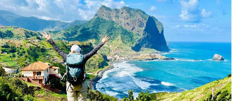
Top 11 Hikes in Portugal
With so many trails crisscrossing Portugal, we’ve done our best to put together a diverse selection of some of its best hikes. We’ve included iconic hikes, off-the-beaten-path ones, and a range of day and multi-day hikes suitable for different levels of fitness and interests.
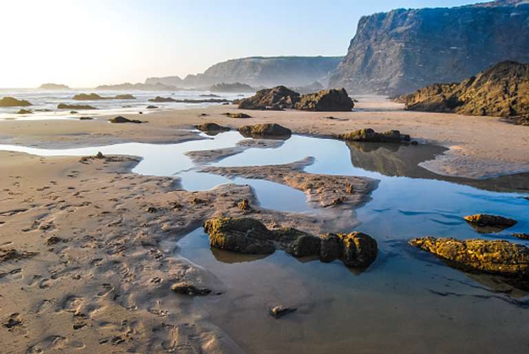
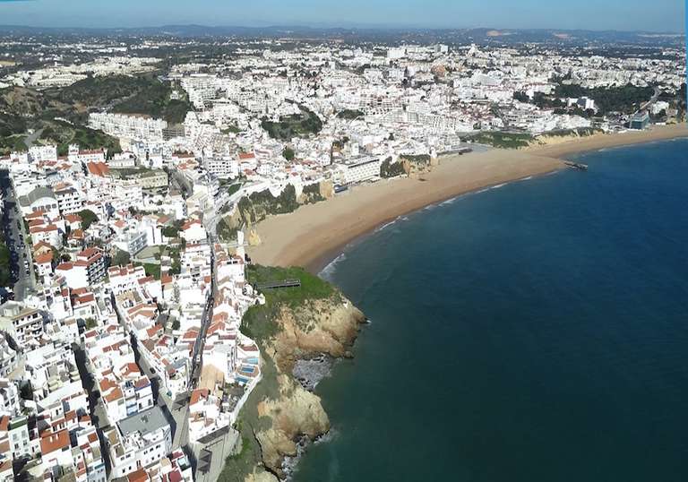
1. The Seven Hanging Valleys Trail, Algarve


This classic Algarve trail of golden cliffs and crashing waves is one of the most popular in the country. With plenty of beaches along the way to stop for a swim, this trail can be hiked even in summer if you don’t mind heat and potential crowds. Don’t miss a photo opportunity at the Alfanzina Lighthouse or the arches at Praia da Mesquita. The route also passes Praia Benagil, home of the famous Benagil Caves only accessible by boat—you can arrange a trip from the beach if you have time, it’s worth the effort. The finish at Praia Marinha is nothing short of spectacular—reward yourself with a dip in the emerald waters and a long lunch.
Hike facts
- Hike type: Day-hike
- Trailhead/end: Praia de Vale Centeanes to Praia Marinha (or can be done as a loop)
- How to get here: 10-minute drive/taxi to the trailhead from the town of Carvoeiro to Praia de Vale Centeanes beach
- Trail difficulty: Easy, with very little up and down. Maintained trail and boardwalk throughout.
- Fitness level: Beginner
- Distance: 5.7 km (one way)
- Duration: 2–3 hours


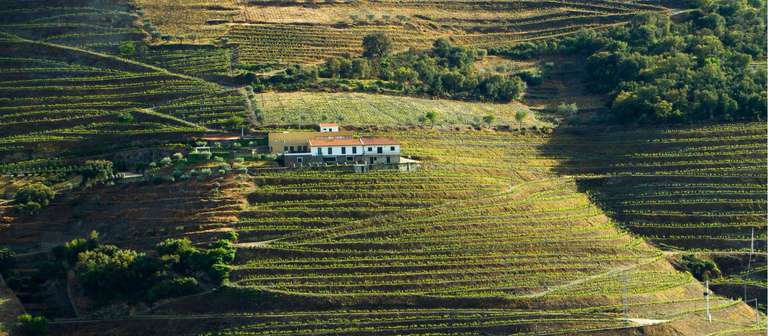
2. Trilho do Vinho do Porto, Douro Valley


This is the hike to do in the Douro River Valley. It offers sweeping views of the terraced vineyards tumbling down to the river and idyllic countryside. This is a relatively easy hike, but the ascent back into town at the end is unavoidable and by far the hardest section. Stop at the luxurious Six Senses Resort for a drink and a rest. Temperatures (and crowds) can soar in high summer. If the weather is wet, the cobblestone sections can be very slippery.
Hike facts
- Hike type: Day-hike
- Trailhead/end: Samodães, forecourt of the village church
- How to get here: Start from the village of Samodães
- Trail difficulty: Moderate. Relatively easy path, but the toughest section is at the end hike from the river back into town.
- Fitness level: Intermediate
- Distance: 8 km (roundtrip)
- Duration: 2.5–3 hours

3. Vista Do Rei Loop Of Sete Cidades Lake, the Azores


Miradouro Vista Do Rei is one of the most famous and popular spots on the island of São Miguel. The views take in the caldera of Sete Cidades and its two beautiful contrasting lakes—one green, one blue. The hike starts from the viewpoint and does a loop around the lakes offering myriad viewpoints and perspectives of the stunning landscapes and a chance to leave the crowds. At an elevation of nearly 550 meters, the viewpoint can be prone to fog, blocking the view and making the path dangerous. Views are clearest in the summer months. We also recommend downloading the SpotAzores app which links you to webcams all over the island so you can check the weather.
Hike facts
- Hike type: Day-hike
- Trailhead/end: Vista Do Rei Viewpoint
- How to get here: Drive to Vista Do Rei, avoiding the carpark at the viewpoint which only has 20-minute parking, there is a long-term car park just over half a mile east of the short-term car park.
- Trail difficulty: Moderate, mostly flat with some up and down.
- Fitness level: Intermediate
- Distance: 13.8 km (roundtrip)
- Duration: 4.5 hours
Check out our list of the best hikes in the Azores for more options.
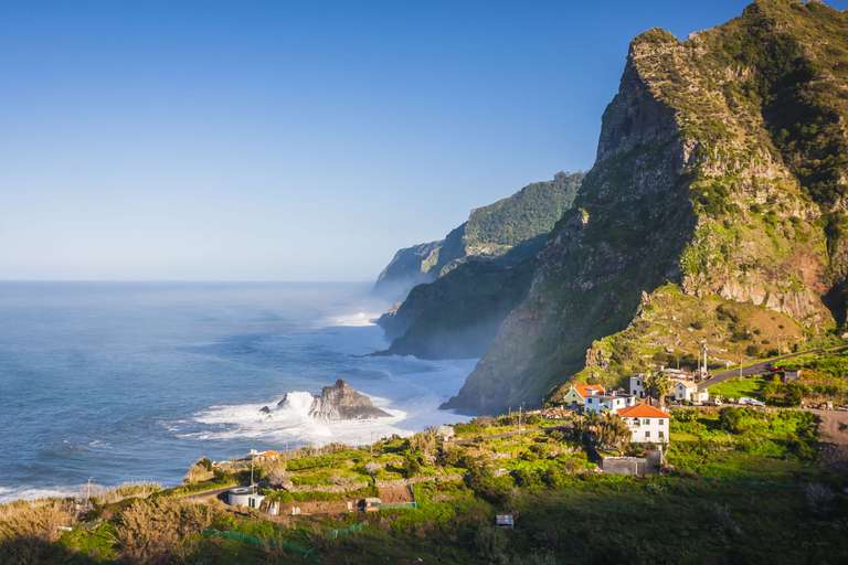
4. PR6 Levada Loop to 25 Fontes, Madeira Island
 where 25 waterfalls pour into a beautiful lagoon. It is possible to swim, but the water remains very cold year-round.")

One of the most popular hikes on Madeira with tourists and locals alike, this path winds through lush, dense forest and crosses some of Madeira’s famous levadas—a series of impressive channels and aqueducts running along and through the island’s mountains. There is a well-marked option on the trail to take a short detour to the impressive Risco Waterfall which tumbles over 90 meters down a sheer cliff face into the basin below. The hike culminates at the famous 25 Fontes (25 Fountains) where 25 waterfalls pour into a beautiful lagoon. It is possible to swim, but the water remains very cold year-round. In the summer months, when there is less rain the flow of the waterfalls is less. We recommend starting early in the morning (especially in the summer months) to beat the crowds.
Hike facts
- Hike type: Day-hike
- Trailhead/end: Regional road ER 105 in Rabaçal
- How to get here: From Funchal drive/taxi one hour to Rabacal where there is free parking. From the parking lot, it is a 10-minute walk to the trailhead.
- Trail difficulty: Moderate with some steep sections and can be slippery when wet.
- Fitness level: Intermediate
- Distance: 8.6 km (roundtrip)
- Duration: 3 hours
5. Paiva Walkways, Aveiro


Consistently ranked as one of the best hikes in Portugal, this inland route follows the rugged and meandering Pavia River, a tributary of the Douro. If hiking one-way, start at Areinho for a less demanding hike (if doing a return, start at Espiunca to get the 400+ steps up out of the way early). There are cafes and toilets at both trailheads and plenty of taxis to ferry weary walkers back to their cars. The path gets busy in the summer months, particularly on weekends and public holidays. Daredevils will want to cross the 516 Arouca suspension bridge—at nearly 182 meters high and 520 meters long, it is one of the biggest in the world. Crossing the bridge is optional and requires a separate ticket. There are three lovely riverside beaches along the route, one at each end and one in the middle, which is the perfect spot for a picnic or mid-trek swim.
Hike facts
- Hike type: Day-hike
- Trailhead/end: Areinho or Espiunca
- How to get here: 25-minute drive/taxi from the town of Castelo de Paiva or about an hour from Porto or Aviero. Trailhead is in the Arouca Geopark (it is essential to book a ticket online).
- Trail difficulty: Moderate, well-maintained walkways, but there are sections with lots of stairs.
- Fitness level: Intermediate
- Distance: 8 km (one way)
- Duration: 3 hours
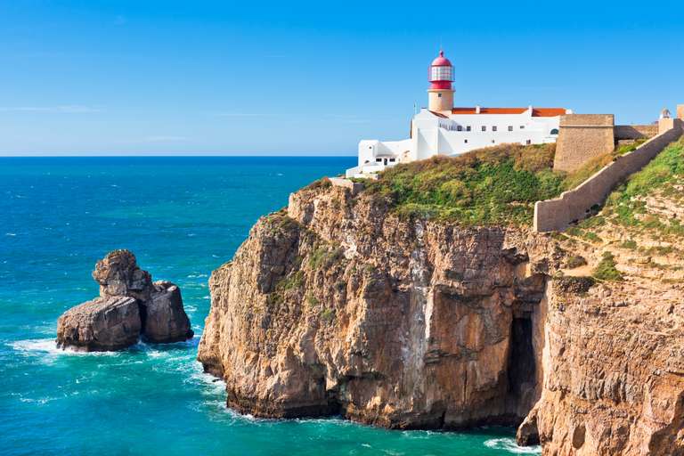
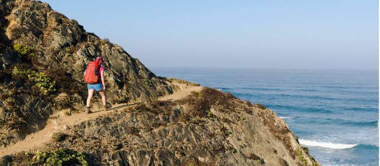
6. Fisherman’s Trail, Alentejo


One of the world’s great long-distance coastal walks, the Fisherman’s Trail takes in all the highlights of the Portuguese coast: rugged cliffs, golden beaches, sleepy fishing villages, and wild landscapes. Starting about 160 km south of Lisbon, the trail hugs the Atlantic Coast all the way to the historic city of Lagos in the Algarve. Given the length of the hike, a great option is to plan your route well in advance and use a luggage transfer service so that you only need to carry a day pack while walking. The trail is also best avoided during July and August when temperatures peak and there are crowds of day hikers in popular sections.
Trek facts
- Hike type: Multi-day hike; however, any section of the trail can be done as a day hike or shorter multi-day hikes. We highly recommend the final section known as the Ponta da Piedade Trail from Praia da Luz to Lagos.
- Trailhead/end: Praia São Torpe, just south of Sines to Lagos, Algarve
- How to get here: Take a taxi or direct bus from Lisbon/Porto Covo to Praia São Torpe and head south along the beach. Some travelers do prefer to skip this section as it is a lot of walking on sand and starts from the town of Porto Covo about 10 km south.
- Trail difficulty: Challenging due to the length of the walk (especially without rest days). There is some up and down over rugged cliffs and walking on sand/dunes.
- Fitness level: Advanced, due to the distance of the journey.
- Distance: 226 km (one way)
- Duration: Average of 11-13 days at a moderate pace.
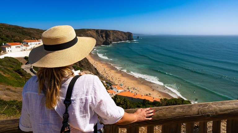
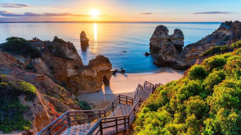
7. Praia Grande Beach To Cabo Da Roca, Sintra

One of Portugal’s finest coastal walks, the track offers incredible ocean views, stunning cliffs, caves and rock formations. As you start, don’t miss the dinosaur footprints embedded in the cliffs of Praia Grande. The end point of Cabo da Roca has an impressive cliff-top lighthouse and is the westernmost point of continental Europe. Make time to stop at some of the beaches along the way—Adraga Beach makes a particularly good pit stop with an on-site seafood restaurant and toilets.
Hike facts
- Hike type: Day-hike
- Trailhead/end: South end of Praia Grande Beach to Cabo Da Roca
- How to get here: Praia Grande is about 26 km northwest of Sintra. It can be reached by a 20-minute drive/taxi from Sintra or a 35-minute drive/taxi from Lisbon. From Cabo Da Roca, it is possible to get a taxi back to your car or there are bus connections to Cascais with onward train travel to Lisbon.
- Trail difficulty: Moderate with a few steep sections. Single-track dirt trail with some sand and loose rocks.
- Fitness level: Intermediate
- Distance: 7 km (one way)
- Duration: 3 hours
8. Caminho Central de Santiago de Compostela, Porto to Santiago de Compostela


One of the world’s great pilgrimages with a history dating to the 9th century, this trek culminates at the Cathedral of Santiago de Compostela in Galicia, Spain, where it is believed that the remains of Apostle St James the Great are interred. This central route is mostly woodland and fields, passing through charming historical villages and towns which provide plenty of places to sleep, rest and eat. May and September are the most popular months for this trek. It is possible to hike it year-round, but be wary that some accommodations close in the winter. Upon completion, you can receive a Compostela certificate, which confirms you have completed the pilgrimage—you must have walked a minimum of 100 km to receive your certificate, so make sure you remember to collect your stamps along the way as proof!
Trek facts
- Hike type: Multi-day hike, it is possible to do longer (start in Lisbon) and shorter (start in Tui) variations of the hike but it does not work as a day hike. There are also popular coastal routes.
- Trailhead/end: Sé Cathedral in Porto to Obradoiro Square, Cathedral Santiago de Compostela, Spain
- How to get here: Arrive at Sé Cathedral in Porto, located in the heart of the Old Town
- Trail difficulty: Challenging, due to the distance and with some steep ascents and descents.
- Fitness level: Advanced
- Distance: 260 km (one way)
- Duration: 12–14 days, averaging 19–22 km per day.
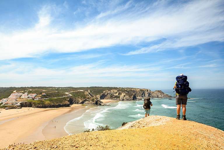
9. The Historical Way (Inland Section)


Paired with the Fisherman’s Trail above, the Historical Way makes up the famous Rota Vicentina. Although part of the same trail system, the two routes are very different. The Historical Way is entirely inland, passing through idyllic countryside and sleepy white-washed villages where time has largely stood still. If you want to escape the crowds, this route is far less busy than the coastal treks in the area and provides an authentic look at rural life. This trek is best in spring and fall; inland routes can be ferociously hot in the summer and cold and wet in the winter. This trek starts at the impressive hilltop castle and church of Santiago do Cacém—make sure you take a few minutes to look around before setting off!
Trek facts
- Hike type: Multi-day hike
- Trailhead/end: Santiago do Cacém, Alentejo to Odeceixe, Algarve. From Odeceixe it is possible to continue on the Fisherman’s Trail to Cabo de São Vicente, adding an additional 260 km and 11 days.
- How to get here: Santiago do Cacém is accessible by a two-hour bus journey from Lisbon; there are also connections from other local cities/towns.
- Trail difficulty: Moderate, with some steep ascents and descents.
- Fitness level: Intermediate
- Distance: 120 km (one way)
- Duration: 6 days
10. Piódão to Foz d’Égua Loop, Coimbra


Nestled deep inside the Serra de Açor (Goshawk Mountains) of the Coimbra region, this hike links the two charming, medieval schist villages of Piódão and Foz d’Égua—making it one of the best interior hikes in Portugal. The scenic path winds through eucalyptus forest, olive groves, and old stone buildings before descending into the postcard-perfect terraced village of Foz d’Égua. In warmer weather, you may want to cool off with a dip in the two mountain streams that flow past the village. This hike is doable year-round but can be slippery in wet weather. We highly recommend taking time to explore both villages; Piódão is more accessible, busier, and more touristy than Foz d’Égua, but both are charming.
Hike facts
- Hike type: Day-hike
- Trailhead/end: The square before the Igreja Matriz to the Museo de Piodão at the edge of the village.
- How to get here: The village of Piodão is about 1 hour 40-minute drive east of Coimbra city.
- Trail difficulty: Easy to moderate, mostly well-marked, slippery in wet weather.
- Fitness level: Beginner to Intermediate
- Distance: 6 km (roundtrip)
- Duration: 2 hours
11. Pico do Areeiro to Pico Ruivo, Madeira


Linking Madeira’s third highest peak, Pico do Areeiro, with the highest—Pico Ruivo—this challenging but immensely rewarding hike offers unrivaled views over Madeira’s rugged mountain landscape. The trail hugs perilous mountain ridges and winds through dark tunnels; if you suffer from vertigo, this may not be the hike for you. A bucket-list hike for any serious walker visiting the island, this trail can get very crowded and we recommend starting as early in the morning as possible—ideally 5:30 or 6:00 am (this will also allow you to catch a spectacular sunrise and get a parking space). Good hiking boots are essential on this route, and there are no toilets or garbage facilities, so be prepared to take everything back with you.
Hike facts
- Hike type: Day-hike
- Trailhead/end: Pico do Areeiro
- How to get here: It is possible to arrange a round-trip transfer/taxi from Funchal, about 40 minutes away. If self driving there is parking at the trailhead, but it fills up quickly. There is an overflow car park just over half a mile downhill from the main lot, so it does add to your total hike.
- Trail difficulty: Challenging. Here are several steep sections, including stone steps carved into the mountainside. The trail can be very slippery in wet conditions and early in the morning. The path is well-marked and there are handrails and chains in some of the toughest sections.
- Fitness level: Advanced
- Distance: 10 km (roundtrip)
- Duration: 4–5 hours
The above list includes some of our favorite as well as the most famous hikes in Portugal. While many of these hikes can be done on your own, for the more challenging trails we advise you to find a credible guide. Regardless, always practice caution on the trail and enjoy the journey as much as the destination. If you are looking for assistance with putting together the hikes, reach out to our local travel experts for a personalized Portugal tour. We also have pre-packaged hiking tours in Portugal that you can join.